click banner sign to go to our main home page


Museum & Family History Research on Fridays in the Old School Rooms, a marvellous display of life in Sutton and Wawne in times past; much more to see when you visit .. Incredible list of resources. Use also with FAMILY HISTORY button below ... Wawne Village, links to church, Village Hall and history Family History enquiries and list of resources for St James', & St Peters's, Wawne ; Resources list as of 10 May 2011 .. Use also with OLD SCHOOL button above ..    dozens of links to military history, both local,	national and military, including both World Wars, all armed services, and more    Local Photos & Images of Sutton & Wawne St James Churchyard - a full list of graves and memorials War Memorials .. photos of all war graves added nov 2009
M A P S   &   G U I D E S
to our villages, plus a brief look at what records we have
the guide to "THE GROVES" is now further down the page
Founded by Merrill & Peter Rhodes over 30 yrs ago ~ The Old School Museum ~
Our historic area also covers Stoneferry, Wilmington and
St Marks in The Groves. Perhaps we should have called it

The Merrill Museum, it would have been very appropriate

     our old Sutton School clock. It used to hang over the 'little wicket door' in the folding screen, on the main hall side, so just above the school office

celebrating    ancient   villages   linked   by   a   shared   history

Folk Museum & Family History Centre
inside The Old School

manned entirely by friendly volunteers ~~ and we need more !
we help to research Family History in the area and celebrate its social history through our superb collections of artefacts and photographs

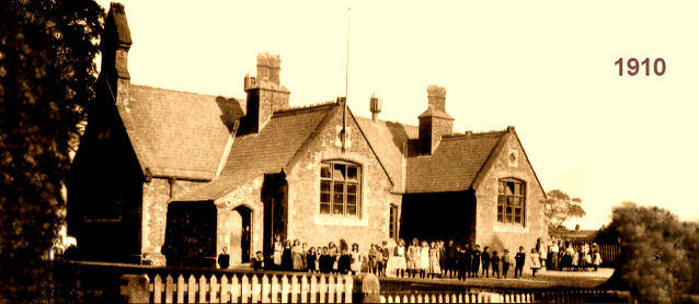
Grade II Listed    built 1859
click here for full image

the oldest former council school in Hull
still used for educational purposes

the Main Museum page, for notices of events at the Old School, new items, school and family visits, etc.
Click this image to view Inter-Active Image of Sutton on Hull - just click on a feature, like St James' church, the Museum in the Old School, Village Hall, churchyard, war memorial, etc - to take you to more information. Image courtesy of Bing Maps, Simmons & Getmapping Plc
Sutton & Wawne Museum, the way in ...
Click this image to view Inter-Active Image of Wawne - just click on a feature, like St Peter's church, Village Hall, etc - to take you to more information. Image courtesy of Bing Maps, Simmons & Getmapping Plc
go directly to the excellent and most acclaimed Sutton & Wawne Museum .. a side menu button is further below view the Museum Page go to Family History pages and lots of helpful links

Click the bar of chocolate to see a History of The Old School


Accessing Our Site
There are several ways to access all of it,
via the many other 'links' scattered around this page.
For family historians, there are the lists of graves in
St James' and St Peter's churchyards,
pages on the history of both churches, and the photo collections
from past vicars and headmasters plus written archives of local families.

For Social Historians, we have a veritable 'museum' of folk history,
with hundreds of artefacts on view representing
every-day village life in decades past.
If you happen to have reached this page directly and
the side menu is not yet visible, you can click
the green button below to access it.

Several links are also on the inter-active aerial views
of each village, shown just below here. Clicking on the
Churchyard in Sutton goes directly to the list of graves,
or clicking on the Village Hall in Wawne goes to their website.

TABLET BROWSERS:
Viewing this site on a mobile phone is problematic; even
tablet browsing is not easy, but being able
use your phone in 'landscape' mode and just
using the buttons below helps a little.


       we have free Wi-Fi inside the Old School - do ask a volunteer for the code       

More Nav Buttons for Tablet Browsers
also at the very top, and very end, of this page

our FACEBOOK page

Google+

IMAGE MAPS

Inter-Active Image - just click on a feature, like the church, the Museum in the Old School, Village Hall, etc - to take you to more information. Image courtesy of Bing Maps, Simmons & Getmapping Plc St James' Church pages Wedding Green - click to see how to book Your Wedding at St James War Memorial to both World Wars, plus 14 War Graves inside the churchyard The Churchyard and MI's, including the 14 War Graves the Sutton & Wawne Museum and Family History Centre located inside The Old School, a venue that can also be hired for your small occasion The Village Hall The Vicarage to St James' Church St James' Church Office Reading Rooms: Sutton Sports & Leisure The Ship Inn ... on FACEBOOK The Duke of York Inn The Courtyard - for plants, flowers & ornaments, call 07932 944437 for details of what's in Old Railway Station Lowgate Garage - just off this picture, to the right of the Duke of York this road leads south, eventually to Rob's Photo Restoration & Repair service; true, it's outside the parish, that is your Webmaster! this road also leads south to Rob's Photo Restoration & Repair service The Village Pantry, off the map to the right further along Church St, for a most delicious breakfast, afternoon tea and catering for all small occasions
  Hover your mouse over areas of either of these images, such as the Churches, churchyards, Village Halls or Schools, and
you'll find that various areas and buildings are 'clickable' and takes to a relevant page.
If the mouse arrow changes to a hand with a pointing finger, try clicking it ....

the medieval 13thC St Peter's Church Wawne Village Hall ... for masses of info on parish, policing, events and community matters Wawne Primary School The Post Office this lane leads to the historic Wawne Ferry the lane to Meaux Abbey Waggoners Arms ... no website yet The site of the old Humberside County Council Cold War Nuclear Bunker .. not open to the public, being converted now to a private bungalow Wawne, the Windham Family and deeper Wawne history The road to Sutton on Hull even deeper history from the Domesday Book the modern Wawne listing on Wikipedia Wawne Convenience Store and Shop Churchyard, photos of church, and links to buy MI books

LINKS UPDATED: Sept 2022 : : : : : Convert this aerial image to a Street Map showing main buildings;
use Backspace key to return to aerial view. All the links in this IMAGEMAP, except St Peter's Church,
leave this site and then open in a new browser window.

Additional to the Image Map above, with it's clickable links, there's a Wawne photo website, by Barbara ... excellent!
Postcode: HU7 5XA ::: click image to go to St Peter's, Wawne, also to a link to the new independant Wawne Village Website go into our little museum
Postcode: HU7 4TL ::: click to go to all known graves and monuments in our churchyard, and click the music button at the bottom of the Menu Bar on the left to hear a short peal of St James' bells.


M A P S

z
Bus Map for Sutton

Church Street - main buildings
Streetmap - map of Sutton area ....
Streetmap - map of Wawne area ....

all open in new browser tab . . .
. . . but do bear in mind that Church St has a rather deceiving bend,
right outside the church where, incredibly, parking is allowed on both sides!
Deceiving because, also, the road narrows there too, right at the 'kink'.
The 'simplified map' on the right does not show that bend. Beware, especially
of delivery vans and buses; it's a busy two-way bus route, every 10 mins.
The photo is Google Streetview; the 2012 picture.  >> See what I mean!
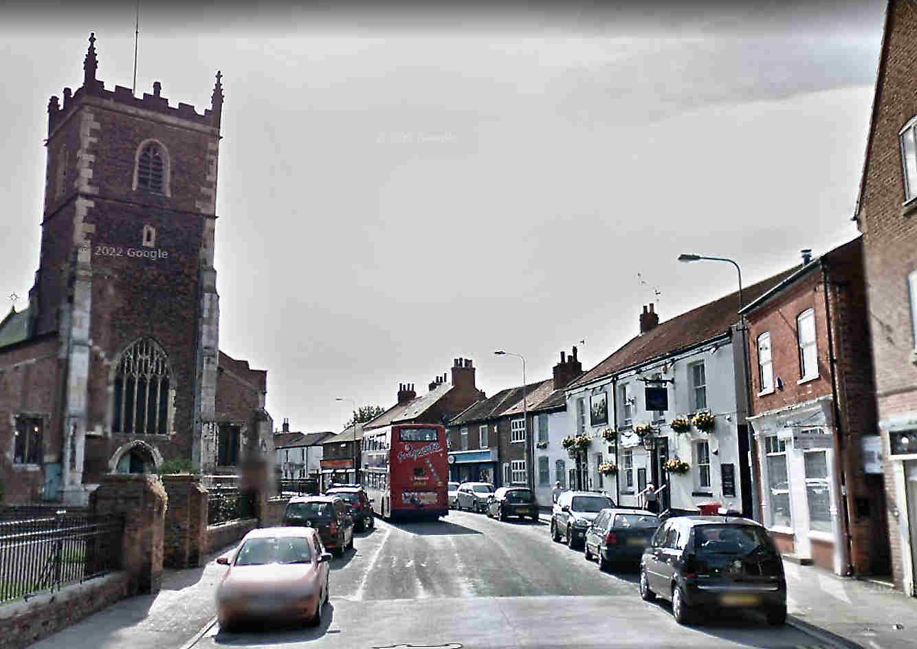
Mind how you go . . . and your mirrors !

You can also now find the museum listed on Google Maps !

There's yet more maps,
ORDNANCE SURVEY,
NATIONAL LIBRARY OF SCOTLAND old Maps of England,
GOAD MAPS
Click the Link to our other Family History Links Page ....
Opens in this same window.

Our What3Words are : tune.amount.orchestra .. in an emergency,
they literally bring help to our front doorstep!

And if you enter HU7 4TL into your SatNav, you'll be here in a flash!
It's the same code used for Weddings, Baptisms, etc, at St James' Church

Google have also given us a 'business website'
which may suit viewing on a phone or tablet better.
http://suttonandwawnemuseum.business.site/


See also the new Multimap links below
for new aerial photos of both villages.

If you want to just browse the maps, we now have all the maps
All On One Page
All are either on this site somewhere, or have been in the past.
Many are decorated to use as backgrounds, but in most cases,
interesting information was not obliterated. They may still be of use.

There's
at the bottom of this page -- sample maps of Sutton and Wawne
Old-Maps.co.uk have gone; we now have to use maps provided by the National Library of Scotland, who host maps for the whole country. They're not quite so easy to load, and the historic reference don't go so far back in detail. The best early maps of Sutton and Wawne are now 1910: before that, to the 1850-80s, those maps are 1:10,000 and not of great detail. We can only use what we can obtain, for free. So long as they are free, which may not be forever.

Click this link to see my extract of the map of old Craven Park
around 1928, and you'll see what I mean about how good they were.
Every tram track, every garden and outhouse ...
but this is a 10% compressed reduction!
(the good news is these can be found on NLS now too!)


Use this page also in conjunction with the
Family History information and Other Links pages

for all information on the lists, archives and records here at Sutton,
click the FAMILY HISTORY button below.

If you like maps, good maps, AND photos, this site link below will
keep you up all night. Geograph have the aim of showing at least
one photo in EVERY 1km square of the Ordnance Survey
maps of Great Britain. There are already lots of photos
of the Hull and Sutton area, and I mean LOTS, and thousands of
stunning photos from all over the country - add yours to them!
(opens in a new window)
GEOGRAPH.ORG.UK


  One particular local photographer is Sutton's own Bernard Sharp. We now have his 7th Edition of the graveyard photos DVDs. All the previous editions have proved invaluable both to us in the museum, as well as to visitors looking for lost graves. There are well over 2,000 grave and monument photos. But Bernard also has over 7,000 photos posted on GeographUK, of the wider Hull area, and they're well worth a browse by themselves. You can view them by Thumbnails, or as a Slideshow. The link below is to nearly 300 of Bernard's Sutton on Hull photos alone, and it opens in a new window.   BERNARD SHARP'S SUTTON PHOTOS on GEOGRAPH-UK

A full list of all the graves in both churchyards, St Peter's and St James',
are on this website at GRAVEYARD LISTS.   Photos supplied via email on request.


Museum & Family History Research on Fridays in the Old School Rooms, a marvellous display of life in Sutton and Wawne in times past; much more to see when you visit .. Incredible list of resources. Use also with FAMILY HISTORY button below ...
Upcoming Events, commemorations or celebrations
Friends of The Old School ... we need you !! An up-to-date list of our Friends is now on this page
Family History enquiries and list of resources for St James', & St Peters's, Wawne ; Resources list as of 10 May 2011 .. Use also with OLD SCHOOL button above ..
potted Church Histories for St James', & St Peters's, Wawne
Wawne Village, links to church, Village Hall and history
Sutton War Memorial .. photos of each war grave now added, Nov 2009
Wawne War Memorial
leave these pages to visit the Commonwealth War Graves Commission website to research any war dead, in both World Wars, for all Commonwealth forces that took part ....
Wawne Ferry .. a couple of pictures

our FACEBOOK page

UP

THE HOME PAGE ...


A QUICK NOTE ABOUT TABLET
AND PHONE BROWSING :


A couple of our experimental videos ...
just trying the sounds,
trying to capture the mood of
St James' churchyard, are at the bottom
of the Photos Page, after GALLERY 4.

Sutton on Hull is near Kingston upon Hull. Wawne is 3 miles nor'west of Sutton. see map
our website is hosted by Free Virtual Servers
send an EMAIL to us direct to the volunteers at the Sutton & Wawne Museum
Do visit our Guestbook; now over 160 entries from all over the world.
Top of Page
Local Photos & Images of Sutton & Wawne
dozens of links to military history, both local,	national and military, including both World Wars, all armed services, and more
General Links, many local to Hull and the East Riding ; includes many Family History links, with an emphasis on links to the Armed Forces and their associations.
The Old School in Sutton, history of the original school, is available to hire for groups, meetings, lunches, etc ... or click MUSEUM button above for Family History
St James Churchyard - a full list of graves and memorials
books, DVD, pamphlets, etc, to do with local history or interest.
leave these pages to visit Brooklands Photographic Society, Sutton RAF Sutton on Hull page
Rob's Photo Restoration & Repair Page ... click button for more details

our FACEBOOK page


NEXT


DVD out NOW !!
SUTTON DVD
click to see more details
of this 80-min DVD


The Photo-DVD
of Merrill Rhodes' book can
also now be purchased as a
digital download for just �5.
click here to download a
short PowerPoint file

(15Mb in 20 slides)
for a preview of contents;
More details, formats, etc, on our
PUBLICATIONS PAGE

note: this DVD is made for
computers, PCs and laptops;
not suitable for TV
or domestic DVD players.

Here in the Museum inside the Old School
WE HAVE RECORDS awaiting your examination !
Some 22 books of photos of Sutton, and 5 of Wawne, in decades past, many dating back to before the First War, have all been archived and card-indexed for easy searching. 22 Sutton Photo AlbumsAs donations of new photos come in, they are archived and added to the collection, so it continues to grow year on year.
Wawne Photo Albums Additionally, there are our copies of the old School Registers, dating from late Victorian days to around 1972, shortly before the school closed.


5 Wawne Photo Albums The final four years were lost when they suffered a flood at the new St James' School on Dorchester Road.

Wawne Photo Albums

Sutton School Registers

Sutton School Registers
[left]


OUR MUSEUM SHOP


where our DVDs,
local interest
books, etc
are on sale
every Friday


The photo below
is a good example
of the dozens of
images that we hold
in our extensive
photo archive.


Click to enlarge it.

This class of girls
mostly seem to
enjoy having their
photograph taken ...
but not all, it seems.


the view from the top

A new page dedicated to publications of
DEEPER HISTORY
is to be found on our
ONLINE eBOOKS PAGE

heaven's bells


SUTTON     and     WAWNE
Where are we . . ?   where are these ancient villages in relation to each other ?

And what, or where, were 'The Groves?'


the map to the right showing their
proximity, on the northern outskirts of
Hull about 3 miles, or 2.7km, apart.


It's hard to credit it now, but there never used to be anything between the areas of those shaded circles, Sutton to the south-east, and the smaller Wawne to the north-west.  Nothing at all, other than a few lone cottages, farms, and one large country house set back from the lane. The whole area would have been  predominantly white on this map.

That brown connecting line with its modern roundabouts is that very old lane, today the Wawne Road - and no longer a quiet country lane. It ran along the low ridge that kept the ancient trackway just above the floodplain, the very track that villagers of old Sutton had to walk to attend mass every Sunday and feast day at St Peter's Church in Wawne.  That was the time when their own church was merely a tiny chapelry of St Peter's, in the early 1300s.  For centuries, until less than 100 years ago, walkers or horse riders along that lane would only have heard the song of the lark, chattering hedge sparrows and assorted other birds, mingled with the bleats of hundreds of sheep - and maybe the occasional beast - in the large fields on either side of the hedgerows.

For over 700 years ago, Wawne was the 'senior' church or village, and Sutton's chapel merely a 'daughter' church. Though an earlier building to the present St Peter's is thought to date from well before the Norman conquest, the earliest known historical references date from 1115.

Until the 'new' St James' at Sutton was built, the one we see today, and then consecrated as a new and separate parish in 1349, all burials had to be held at St Peter's. It was along this green lane that mourners would slowly proceed, carrying their coffin, winter or summer, rain or shine, to bury their dead.

For well over 400 years, life in both villages moved through the various changes and upheavals in English life, occasionally ravaged, touched or influenced by some, but by-passed by many. Kings and Queens, civil wars and insurrections, all came and went, and the area remained a remarkably quiet backwater, even by English standards. Nothing changed much at all until the industrial revolution brought more modern farming implements, or the occasional windmill converted to steam as well as wind. Undoubtedly the biggest changes, and most notably the biggest visible sign in Sutton of that revolution, like thousands of villages nationwide, was the coming of the railway.

From that time on, in 1864, Sutton increasingly became a 'dormitory' village of Hull, and increasing in size year on year as that nearby whaling and fishing town also grew in both size and wealth to give us more or less the shape of the heart of the village in what we see today.

It is my personal belief that had the new railway first taken a slightly more northerly course on leaving Hull, so following lower ground nearer to the river to avoid cutting through the slightly higher ground that was Sutton on its low ridge, it would have passed more equally between the two villages, before then turning roughly east towards Swine as it did after passing through Sutton. Perhaps then the station would have really been titled, "Sutton & Wawne," and Wawne would have benefitted more too. There were many stations so titled when two places shared the same railway. Money often played a big part, when a wealthy landowner paid or bought shares in the railway company so as to have the line pass through his estate, and thereby often got a 'free' station for his own use.

We can speculate that our fabled station might well have been on that same lane, perhaps near where "The Swallow" pub is now just south of the Wawne Drain. The area immediately around would surely have grown up long before it did, just as it has some 100 years later when Bransholme estate was built.

As it was, trudging 3 miles to the nearest station in Sutton was better than having no station at all, or else traverse the muddy 5 miles or so directly down through Stoneferry into Hull. Perhaps there were marginal benefits to Wawne after all.

My circles on the map mark the centre of both parishes, and show both villages appear to be well separated. And so they are now. Newcomers to Hull and it's history could be forgiven for thinking that first Bransholme, and then Kingswood, were always there. But it wasn't always so.

In 2017, Bransholme was just 50 years of age, and the even more recently built Kingswood development was still but a pup and a planner's dream.
The estates, comprising what is now, in effect, a growing small town, were born out of the remnants of what had been the 'Abercrombie Plan' devised for Hull after the massive destruction of the Blitz. As well as slum clearance that would have happened anyway, some 80% of the city's housing stock was destroyed or damaged in the wartime bombing. Hull needed a lot of new homes.  And in the 1950s, it started to grow.

map showing the proximity of our two villages, and the line of the ancient lane that linked them
see more of the map in a new window

Even more folks may be surprised to know that it was never originally intended for Hull's new 'dormitory town' to be built on the flood plain where it is now - but first planned for the slightly more highly elevated fields and woods around either Rise Park, to the north east beyond Skirlaugh, or equally well to the east at Burton Constable! Come into the museum and view our copy of the Abecrombie Plan - we have the maps of what was first proposed and it certainly was not what we have now.

All of Bransholme, Sutton Park and Kingswood, were virgin fields, frequently flooded from an untamed and very tidal River Hull in winter, but dry enough to graze cattle in summer. There were several dairy farms, but two of them, Low and High Bransholme, gave the area it's name today. Wawne Drain, one of several dug by the ancient monks of Meux, was always the boundary between the two ancient parishes, and would be so today had not the very new St John's Church been built on Wawne Road itself, thus making yet another new parish to serve the huge number of new inhabitants of Bransholme.

The Groves
The actual shape of the historic Sutton parish is even more of a surprise, for only a fraction of that old parish is shown on the map above. Until 1887, it's former shape could be roughly likened to this mishapen red kite, where the wobbly tail extended way to the south, right down Cleveland Street to the north side of Witham, and thence north back up Dansom Lane. The west side of the wobbly tail was the course of the River Hull, the far side of which was mostly the parish of Sculcoates. The white cross marks the relative position of St James' Church in Sutton village, inside the red circle on the map above, and the white line that of Witham and Holderness Road today. Below that white line was the adjoining parish of Drypool, and another St Peter's Church, sadly destroyed in the Blitz. We mention those adjoining parishes because so many folks who research their Sutton family history will find those other parish names cropping up in their records too. It's not at all unusual to see a record of a lass born in one parish, married in the next, and buried in another, all close by and abutting each other. For our purposes, we can think of Sutton as being almost central to all those other places named around it.

The green cross is the area of Stoneferry, the mauve cross is Wilmington, and the green circle denotes the area known as 'The Groves', or anciently, the 'Growths'. It was very wet around there, the river bursting its banks with monotonous regularity several times a year during very high spring tides until higher banks and better drainage was installed in Victorian times. In fact, it flooded annually all down Witham to even as recently as the 1950s, and only the building of the Tidal Surge Barrier in 1980 pretty well cured the annual deluge to the low-lying dwellings either side. Click the graphic to enlarge it.  The 'Growths' took it's uninspiring name from the sheer amount and proximity of huge reed beds, fertilised by the regular flooding, several times in some years. They must surely have been tall and dense to deserve the name.

Thus all of Stoneferry, Wilmington and St Mark's in the Groves (or Growths, to give it's even older title) were areas whose inhabitants were often baptised, married and buried at St James' in Sutton village itself, leading to much confusion today amongst family history researchers. As an aside, it's worth pointing out here that another minor point for confusion is that St James' at Sutton is often mistaken for the war-damaged - and long since demolished - church of St James', in St James' Square just off Hessle Road behind the old ARCO building on the other side of the city to the west.

The 1881 Census was the last to record Lime Street and The Groves as being in Sutton Parish. Increasing industrialisation brought the numerous new terraced streets and tiny courts housing those thousands more inhabitants up both sides of Cleveland St. They were folk who would eventually gain their own parish churches - St Mark's consecrated in 1887 was one, St Saviour's at Wilmington was another - and thus the old, huge and medieval parish of Sutton was divided up.

Before we leave 'Lime St' - and The Groves - it is worth mentioning the connection with the famous hymn tune, 'Melita', known to generations of Royal Navy seamen as "Eternal Father, Strong to Save ...". Those now famous words were penned by a Hampshire man, William Whiting, but the man who wrote that just as famous tune was Rev. John Bacchus Dykes, born in 1823 down Lime St here in Hull. He later became a lifelong abolitionist and good friend of William Wilberforce, amongst many others. It is of particular note to us that baby John was baptised in St James' Church in Sutton, perhaps our most notable example of one born so far away from Sutton village but still baptised there, because it was his family's parish, however inconvenient the long walk in those distant days. Another of his many famous hymn tunes, around 300 all told, was 'Holy, Holy, Holy." How many times has that been sung in St James' over the past 150 years and folks had no idea of the connection. A great deal more detail of John's life may be found in a book, FAR HORIZONS, by Robb Robinson of Hull University, available via the University or usual book retailers and similar channels. Hull History centre has research copies.

A 'stylised' map of the immediate Groves area shows the very southernmost extent of Sutton Parish until 1887, St Mark's in The Groves .. click to enlarge though St Mark's Church itself is just off this map a hundred yards to the north, beyond Mulgrave Street. The map can be seen here, on clicking this thumbnail.

The red kite lost its tail.
Or maybe it was a red flatfish.

A much longer description of the whole 'Groves' area, including another map and a tribute to their formerly 'lost war dead', is on a whole page to itself,
HERE, and will open in a fresh page in your browser.

It is because of all that ancient history,
the family connections between the folks of both villages
and all the farms in between, that makes our little museum -
and thus our website - what it is, and what we are all about.


BELLRINGERS REQUIRED !!
Are you a reasonably fit adult?
Could you ring a bell ?
Recruits required to build up our team of bellringers for St James' church.
Anyone can apply, novices welcome; 10 yrs old and above welcome
if accompanied by an adult.
We need 6 bellringers, training given. It's great fun. Come and join us!
Practice night is alternate Fridays. Apply to Gwyneth Moffatt on 377595.


Go to the
CHURCHES PAGE

for information on how to contact the main
parish churches, their clergy and church offices.


The time in Hull shown here is now on GMT


We hope you find these pages of use,
and of comfort, if it is comfort you seek.

Do call again.

We also have a Guestbook, on this new site address
if you'd like to sign it .. ..

... and there's also a Guestbook button in the menu.


Top of Page


our FACEBOOK page

COOKIES !
New legislation came in during 2012 regarding the use of Cookies.
I thought I ought to say a few words regarding Cookies and this site.
Firstly, it's never entered my head to even mention them before, for we do not use them.

It's true; we place no Cookies, on your computer or anyone elses,
nor indugle in any invasion of privacy of any kind. Period.
update; May 2015 : we still don't use Cookies.
Heck! I'm not even allowed biscuits, let alone cookies!

Top of Page


A Sutton Lad
in 1917


by: anonaitch �


We were taught to read
and to write in this school

We were never taught to loathe,
or despise, or to hate.

We didn't want to fight,
or to scorn, or be cruel

Only to read and to write,
have fun, and be late.


~

We left this place so sure
we would return some day.

Very sure we would soon be on
that boat and would come

Once more to this place of youth,
to laugh and to play.

We never thought we'd bury friends
so far from our home . . .
. . . in this cold and foreign clay.


~

By and by, some of us did make it home,
though only as names

To be engraved on stone
so pure and so white

But many, so many, were never
to be found, had no such a grave

But left all alone to sleep,
their sleep of endless, endless, night.


~

We yearned to leave this school,
go out in the world and take part

To make our way, to be rich
or to be poor

We never thought we'd be famous,
huh, for our poor part

In a war that was meant to end,
and put an end to all war.


~

We just wanted to go home
and be all done

With the killing and the fear
and the fight

To return to this school,
once more to have fun

To learn how to read,
to add up, and to write.


Copyright remains with the
Sutton & Wawne Museum


Sutton Remembers


our FACEBOOK page

Top of Page

This Sutton-on-Hull weather forecast
is generated by the Met Office Weather Widget

If anyone still doesn't know where Hull is now,
for all you good people, here's a map of somewhere you may recognise.


Our Museum now has a presence on Google Maps;
you can see us on the same map that gives traffic reports.

Back to the
Top of This Page

our FACEBOOK page


page statistics


broadley


merrill1976pet3r


***